Exploration and Resources
Geology
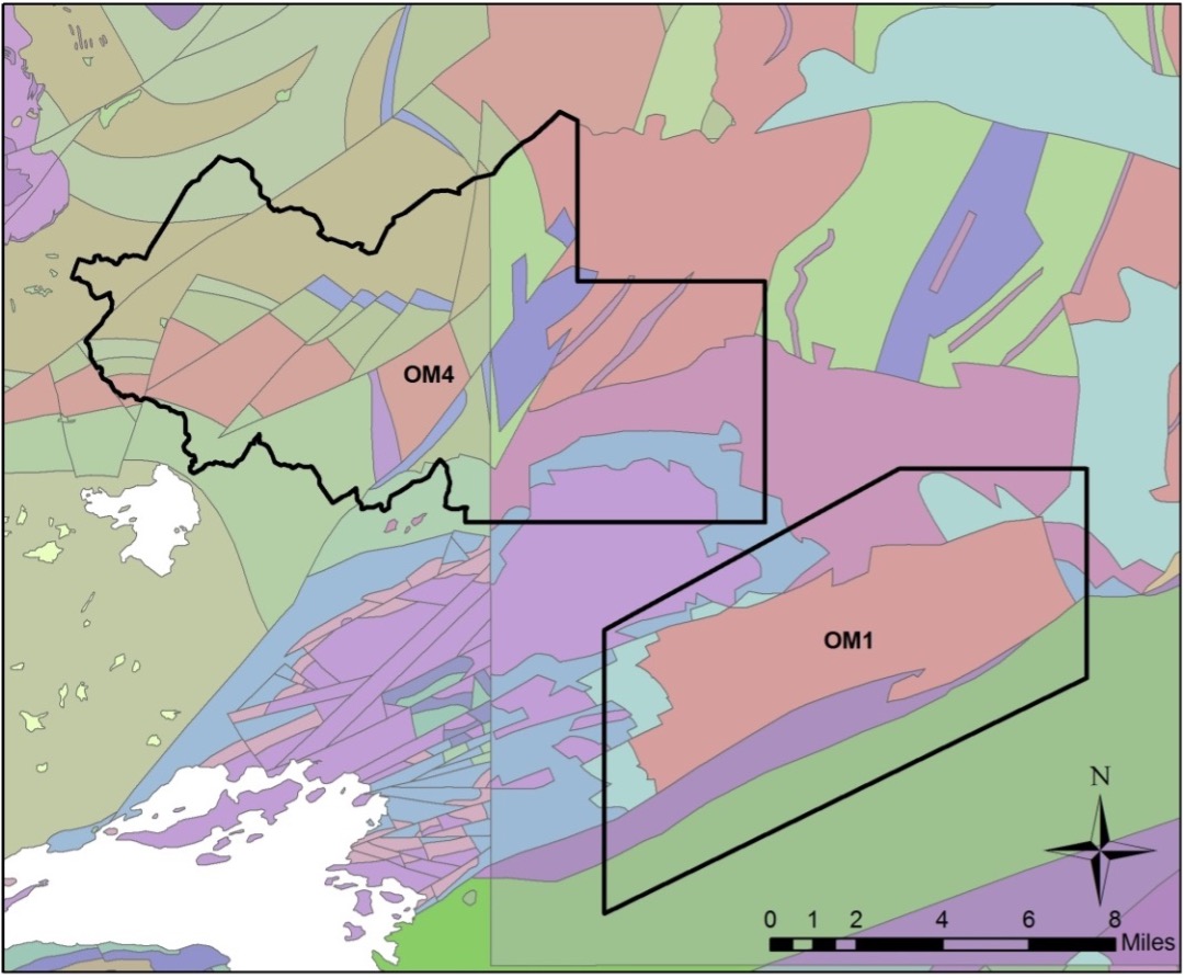
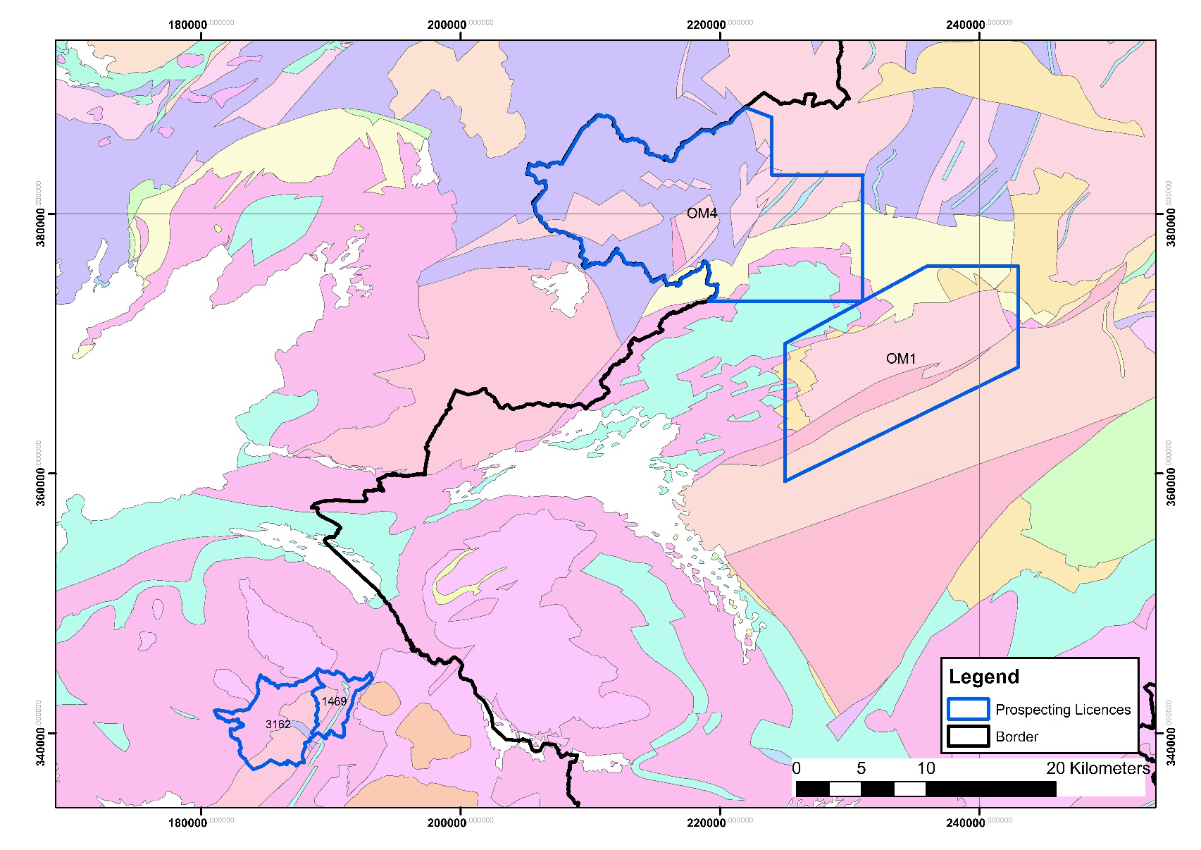
Vein-hosted gold is found within the Dalradian meta-sedimentary rocks in the project’s primary licence area (OM1). The steeply dipping quartz veins are orientated north-south and host sulphide minerals including abundant pyrite and galena. Geological structure exerts a strong control on the location and orientation of the mineralized veins in the Dalradian. The Cavanacaw site lies approximately 1 km north of the north-east trending Omagh Thrust. Similar north-east trending regional faults cut through Dalradian lithologies within other Galantas-held exploration licence areas. In total, the company holds four licences for exploration, two in Northern Ireland and two in the Republic of Ireland.
June 2023 Resource Estimate
|
|
MEASURED |
INDICATED |
INFERRED |
||||||
|---|---|---|---|---|---|---|---|---|---|
|
Vein |
Tonnage (t) |
Gold Grade (g/t) |
Contained Gold (oz) |
Tonnage (t) |
Gold Grade (g/t) |
Contained Gold (oz) |
Tonnage (t) |
Gold Grade (g/t) |
Contained Gold (oz) |
|
Kearney |
94,131 |
6.73 |
20,371 |
402,924 |
6.50 |
84,258 |
402,479 |
5.33 |
69,020 |
|
Joshua |
18,381 |
6.59 |
3,897 |
247,217 |
7.39 |
58,730 |
283,925 |
6.21 |
56,648 |
|
Kerr |
6,848 |
4.63 |
1,019 |
12,061 |
4.34 |
1,683 |
23,398 |
3.20 |
2,405 |
|
Elkins |
- |
- |
- |
68,500 |
4.24 |
9,000 |
20,000 |
5.84 |
3,800 |
|
Gormleys |
- |
- |
- |
- |
- |
- |
75,000 |
8.78 |
21,000 |
|
Princes |
- |
- |
- |
- |
- |
- |
10,000 |
38.11 |
13,000 |
|
Sammy's |
- |
- |
- |
- |
- |
- |
27,000 |
6.07 |
5,000 |
|
Kearney North |
- |
- |
- |
- |
- |
- |
18,000 |
3.47 |
2,000 |
|
TOTAL |
119,360 |
6.59 |
25,287 |
730,702 |
6.56 |
153,671 |
859,802 |
6.24 |
172,873 |
Notes:
- Updated Mineral Resource Estimate for the Kearney and Joshua vein was completed by Micon in June 2023. See Galantas’ July 18, 2023 news release for details and technical report titled “NI 43-101 Technical Report for the Mineral Resources Estimate on the Omagh Gold Project, County Tyrone, Northern Ireland” with effective date June 22, 2023.
- All other veins were not updated during 2023 and therefore remain unchanged from the 2014 Mineral Resource estimate by Galantas as stated in the technical report “Resource Estimate, Preliminary Economic Assessment & Detailed Feasibility Study on the Omagh Gold Project, County Tyrone, Northern Ireland" dated July 26, 2014 and filed on September 4, 2014.
- The 2014 MRE has incorporated a different level of rounding to the current estimate, resulting in the reported contained ounces for the veins being approximated.
- The Mineral Resource Estimate has been prepared in accordance with National Instrument 43-101 (NI 43-101) Standards of Disclosure for Mineral Projects. MRE filed September 1, 2023.
- To demonstrate Reasonable Prospects for Eventual Economic Extraction (RPEEE), underground Mineral Resources were constrained by Mineable Shape Optimizer (MSO) shapes of 1.2 m minimum stope width optimized to a cut-off of 2.25 g/t Au to demonstrate RPEEE.
- Economic parameters for cut-off grade determination: US$1,800 oz Au price, 92% process recovery, 90% payability, 4% royalty, US$120 t mining cost, US$30.72 t processing cost, US$13 t general and administration.
- Diluted tonnages and grades are reported based on minimum stope widths.
- Mineral Resources are not Mineral Reserves and do not have demonstrated economic viability. There is no certainty that all or any part of the estimated Mineral Resources will be converted into Mineral Reserves.
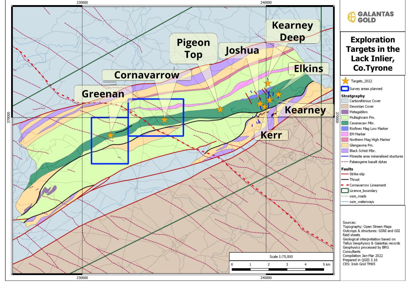
Exploration Potential
Multiple targets have been identified for resource expansion.
|
Target name |
No |
Central grid ref. |
Potential tonnes range (t) |
Potential grade range (g/t Au) |
||
|---|---|---|---|---|---|---|
|
Resource extension targets |
||||||
|
|
|
|
Low |
High |
Low |
High |
|
Kearney |
31 |
H401/710 |
300,000 |
745,500 |
4.5 |
6.7 |
|
Joshua |
32 |
H3970/7072 |
272,000 |
750,000 |
4.0 |
5.5 |
|
Elkins |
35 |
H4061/7130 |
200,000 |
400,000 |
2.0 |
4.0 |
|
Kerr |
33 |
H3995/7065 |
180,000 |
360,000 |
2.0 |
4.0 |
|
Gormley |
34 |
H3974/6982 |
230,000 |
460,000 |
3.3 |
6.5 |
|
Sammy’s |
40 |
H4036/7138 |
30,000 |
60,000 |
2.1 |
4.2 |
|
Princes |
37 |
H3935/7004 |
20,000 |
40,000 |
19 |
38 |
|
Garry’s |
38 |
H3936/6955 |
80,000 |
160,000 |
0.7 |
1.3 |
|
TOTAL |
|
|
1,312,000 |
2,975,500 |
|
|
|
Exploration targets |
||||||
|
Peter’s |
41 |
H3915/7137 |
4,000 |
13,000 |
4.5 |
9.0 |
|
63 Gram |
52 |
H3910/7190 |
33,000 |
101,000 |
4.5 |
9.0 |
|
North of Sammy’s Barn and East Cousins |
28 & 51 |
H3980/7171 & H3980/7183 |
135,000 |
810,000 |
4.5 |
9.0 |
|
Cornavarrow Burn |
4 |
H34977/69417 |
60,000 |
360,000 |
4.5 |
9.0 |
|
Corlea Burn |
22 |
H388/726 |
60,000 |
360,000 |
4.5 |
9.0 |
|
Legphressy |
26 |
H345/704 |
60,000 |
360,000 |
4.5 |
9.0 |
|
Cousins |
50 |
H3925/7120 |
48,000 |
145,000 |
4.5 |
9.0 |
|
TOTAL |
|
|
400,000 |
2,149,000 |
|
|
|
TOTAL EXPLORATION POTENTIAL* |
|
|
1,712,000 |
5,124,500 |
|
|
The potential quantity and grade is conceptual in nature and there has been insufficient exploration to define mineral resources in these areas. It is uncertain if further exploration will result in the targets being delineated as mineral resource. The exploration potential does not represent a mineral resource, does not have demonstrated economic viability and is disclosed in accordance with NI 43-101 Rules and Policies, Section 2.3, disclosed as potential quantity and grade, expressed as ranges, of a potential mineral deposit that is to be the target of future exploration. The disclosed target potential quantity and grade ranges have been assessed based upon the reasonable extrapolation from defined resources and / or surface soil sampling, pionjar sampling, boulder sampling, favourable geophysical or favourable geochemical signatures, the results of which elevate these areas as highly prospective first order targets for further exploration. Howe (2012) carried out a similar analysis of target potential. Most of the target estimates are similar, with the exception of Joshua and Kearney veins. The range of both of these targets has widened. In particular, the Joshua target has increased significantly in the upper tonnage range bound due to an increase in known strike length and the lower and upper grade range bound has increased due to a higher known average grade and greater overall knowledge of grade variation. Source: Galantas NI 43-101 / PERC Technical Report 2014. The Exploration potential of Kearney and Joshua targets will be re-assessed in the light of additional information from underground development and additional drilling.
Targets relative to main Joshua and Kearney veins
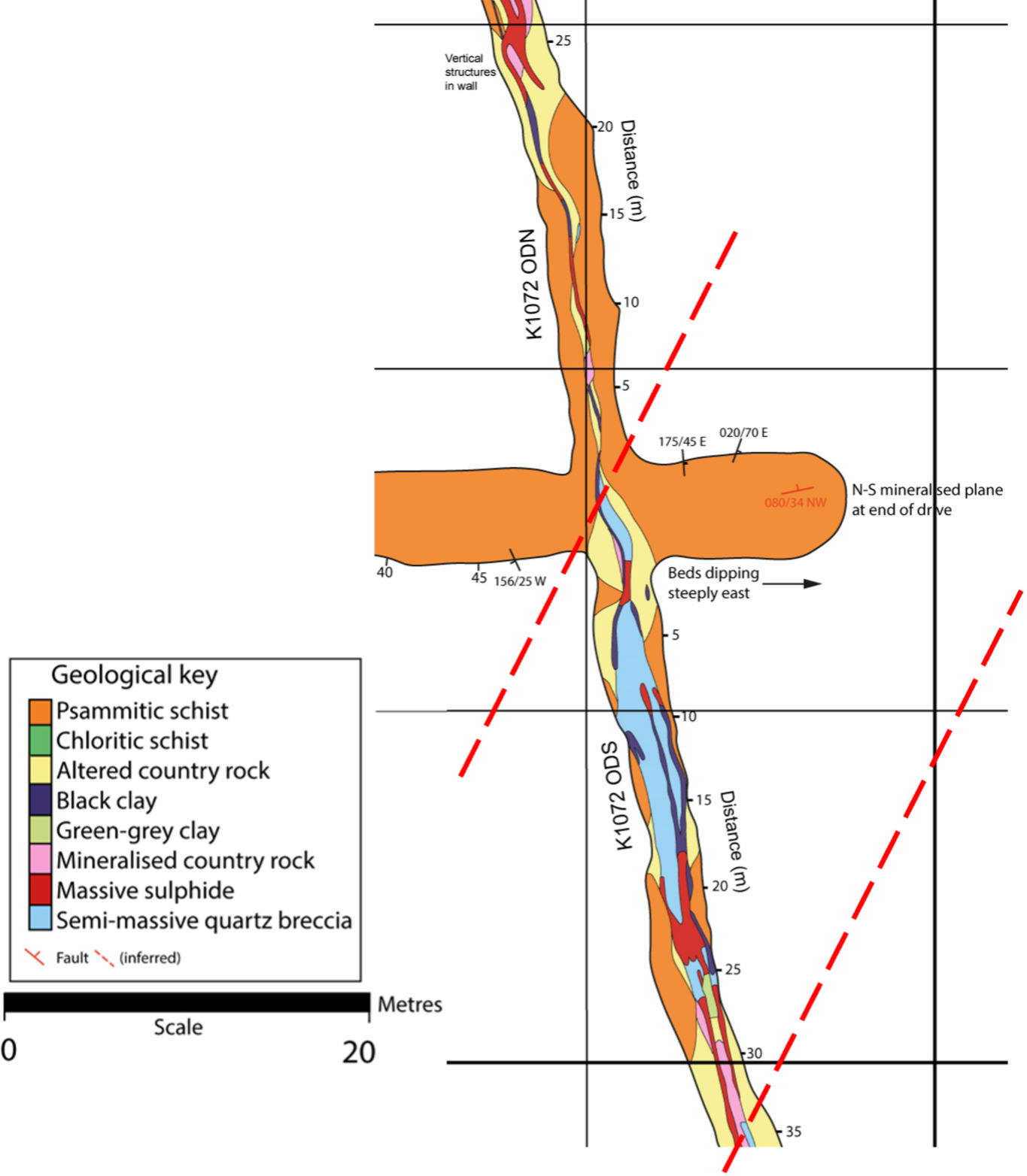
Underground mapping revealed dilation zones
Detailed geological mapping of the development drives revealed a pattern of wider and higher grade areas of mineralization, also known as dilation zones.
The ‘dilation zone’ theory was developed in 2019 and has been sucessfully tested during our latest drilling program.
Dilation zones occur on shallow north dipping planes in both the Joshua and Kearney veins.
Qualified Person
Scientific or technical disclosures in the Exploration and Resources page of this website have been reviewed and approved by Dr. Sarah Coulter, who is considered, by virtue of her education, experience and professional association, a Qualified Person under the terms of NI 43-101. Dr. Coulter is not considered independent under NI 43-101 as she is the Chief Geologist of Galantas Gold Corporation.